

Crisscrossing the Camino - 5 weeks in Northern Spain Part 3: San Sebastian to Santander

SAN SEBASTIAN Camino del Norte
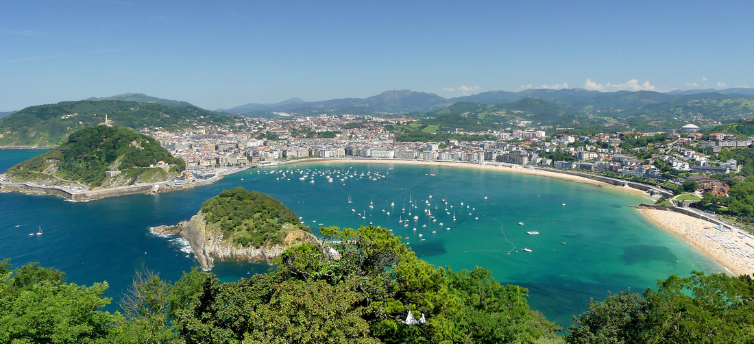
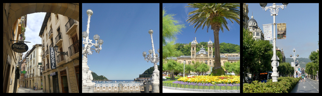
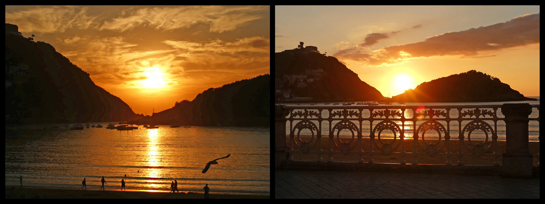
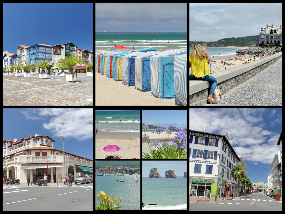
On the Bay of Biscay, 12 miles from the French border, definitely in Basque Country, the city of San Sebastian (Donostia in Basque) was one of the highlights of my five-week trip. The fact that I had great weather and a hotel right in the middle of the Paseo de la Concha may have contributed to my feelings but I think I would have loved San Sebastian regardless. Appropriately, San Sebastian and it’s scallop shaped bay is on the Camino del Norte.
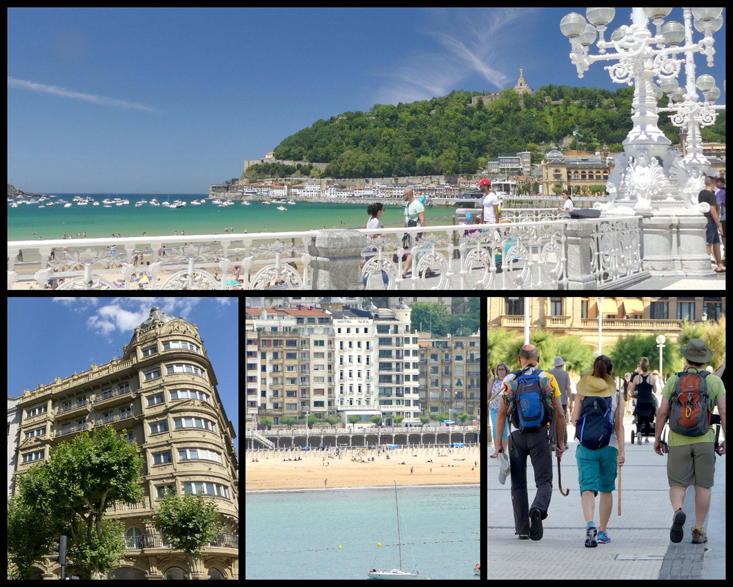
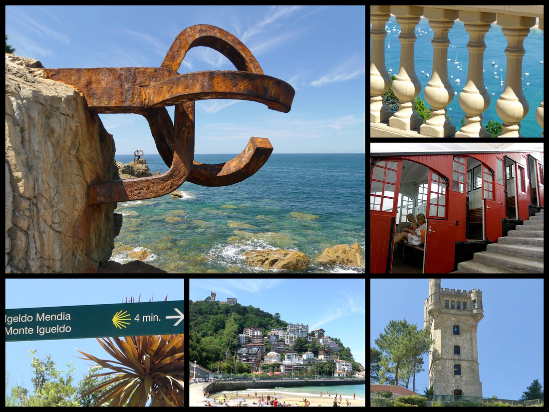
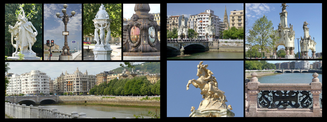
top: Paseo de la Concha bottom left: Área Romántica bottom center: Hotel Niza white building in center bottom right: Camino del Norte
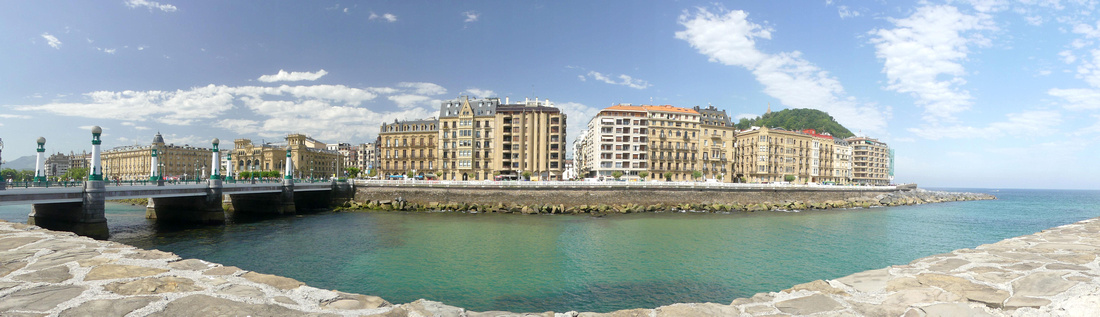
A mixture of Paris and Barcelona, elegant and stately yet with a relaxed beach resort ambiance, centered on the Bay of La Concha capped by twin peaks at each end and a cute little island in the center. The incredibly delightful beachfront promenade, Paseo de la Concha, (2 km) runs the length of the bay, with the old town at one end and a ‘Belle Époque’ shopping district behind. For a century the characteristic and lovingly painted wrought iron balustrade that stretches the length of the promenade has been a symbol of the city, it shows up on everything from jewelry to headboards. The promenade leads at one end to a funicular up to the Mounte Igueldo viewpoint, and at the other end to ’El Muelle’, the little fishing/yacht port, behind which paths wind up to Monte Urguell, topped by the soaring statue of Christ gazing over the city (a kind of Rio de Janeiro aura).
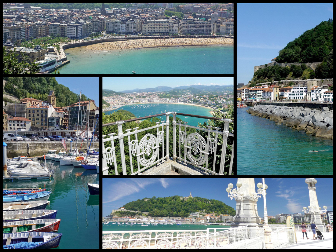
top left: view from Mt Urguell right: Mt Urguell above El Muelle bottom right: Paseo de la Concha with Mt Urguell topped by Christ Statue in the distance bottom left: El Muelle center: view from Mt Igueldo
San Sebastian is a city with about 200,000 population but it feels much smaller. No towering skyscrapers. The Basque culture and language are very apparent there, signs are always in both Basque and Spanish (and sometimes also French, rarely saw any signs in English). People in the tourist trade speak minimal English, but most people were friendly and helpful. I heard a LOT of American English spoken as I walked around the city so clearly it’s on the American tourist map, much more so than other towns in Northern Spain.
I was in San Sebastian four nights/three and half days. One day I took the bus to the Spanish/French boarder towns of Hondarribia and Hendaye and the rest of the time I just wandered around San Sebastian, back and forth all three beaches and their promenades, explored the old town, climbed Monte Urguell and took the funicular up Monte Igueldo. Could have done that for weeks.
San Sebastian has five main areas. The Parte Vieje, ‘old town’, lies across the neck of Monte Urgull, the bays eastern headland. It is neatly underlined to the south by the Alameda del Boulevard whose broad promenade leads into the pedestrianized Parque de Alderdi Eder, which in turn merges with the Paseo de la Concha. South of the Alameda del Boulevard is the sleeker commercial and shopping district, the Centro Romantic [Área Romántica], laid out on a grid pattern with late 19th century buildings.
 narrow streets of Parte Vieje Paseo de la Concha Parque de Alderdi Eder Avenida de La Libertad
On the east side of the Rio Urumea is the district of Gros, with a relaxed ambience and surfing beach of Zurriola. and at the opposite, western end, of the city is Playa de Ondarreta (essentially a continuation of Playa de la Concha), a very upmarket district known as a millionaires' belt on account of its lavish homes.
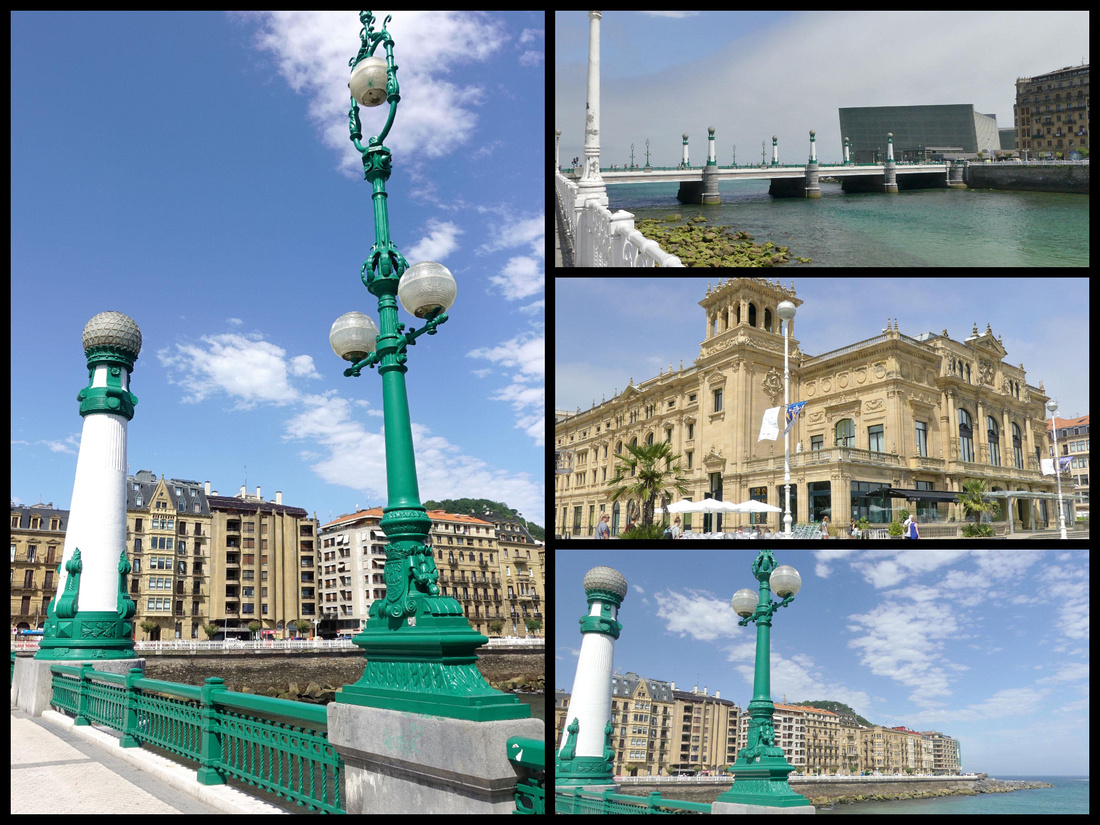
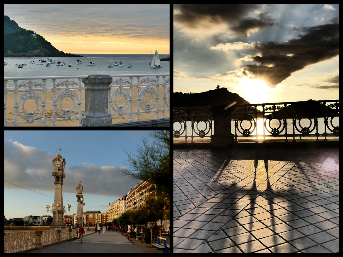
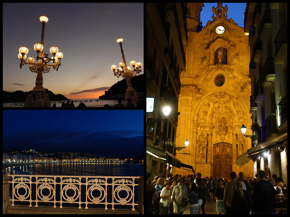
Paseo de la Concha runs along the beach and is full of benches and little trees, most of the time people, and much of the time street performers. There are a few kiosks selling soda and ice cream bars but only a couple restaurants so it all open for strolling and people watching. It’s a nice difference from a lot of touristy places where in the summer it’s wall-to-wall tables and umbrellas. In addition to the gorgeous white wrought iron balustrade there are a pair of huge clock towers and at another point, a pair of huge white iron Belle Époque lampposts. In the center is the Perla Spa Thalassotherapy Centre occupying a couple interesting stone buildings jutting out from the paseo (also the only actual restaurants on the Paseo). (Thalassotherapy is the use of seawater, algae, mud, and other marine items as therapeutic treatment.)
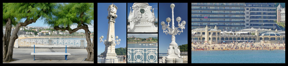
Paseso de la Concha Perla Spa
The Bay of La Concha has very calm waters and the main beach, La Concha Plage has a very wide swath of fine white sand and is frequently awarded ‘most beautiful urban beach’ awards. At low tide the beach is almost 40 meters side. The extension – past the Mirimar Palace, is Ondarreta Plage. The third beach, Zurriola Plage is on the far side of the Urumea River and has larger waves (well, at least they qualify as ‘waves’) so is the surfing beach.
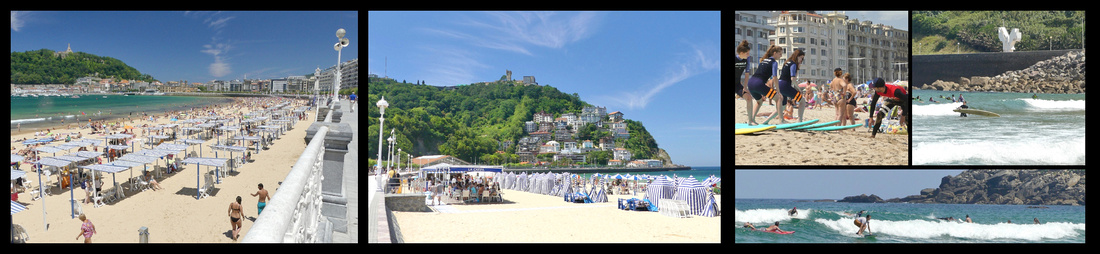
la Concha Plage Ondarreta Plage Zurriola Plage
Palacio de Miramar (Miramar Palace) and park, which divides the crescent in the middle, was where Queen María Cristina resided in 1893, when she made San Sebastian the summer court. She was advised to come here to bath in the sea for health reasons. The Palace is in the Queen Anne Cottage Style.
Antiguo Tunnel passes by the Miramar Palace, joining the two beaches. It is decorated with maritime motifs (supposed to look like the aquarium), one of the legacies of being the European Capital of Culture in 2016.
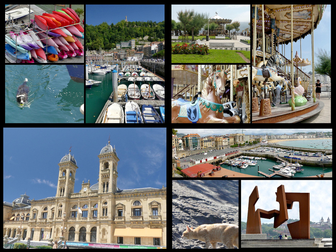
Isla de Santa Clara is a tiny 30-meter-wide island just off the coast. The island has restaurants and picnic areas. During summertime a ferry runs from the San Sebastian harbor to the island.
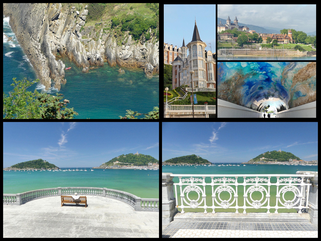
Top left: Isla de Santa Clara top right: Mirimar Palace bottom right & left: Isla de Santa Clara left and Mt Urguell right from Paseo Ondarreta
Monte Igeldo is the higher of the two ‘mini-mountains’ and has absolutely awesome views. There is a turn of the century (Belle Époque Style) funicular which runs up and down every half hour (€3.15 RT). There’s a very old, kind of tacky, little amusement park up there which doesn’t seem to get much action. Virtually everyone just takes the funicular up, gazes at the view and goes back down. The funicular station is just behind the tennis courts where the shore turns.
El Peine del Viento (Eduardo Chillida sculpture), the “Wind Comb” – about 5 minutes past the funicular, at the very end of the promenade are three huge iron sculptures jutting out of the rocks. It’s become one of the symbols of the city. In contrast to the beach area, which has barely lapping waves, the waves crash with some force on the rocks here and can be mesmerizing to watch. I spent at least an hour doing just that (but then I’m easily amused).
El Peine del Viento Monte Igeldo funicular castello Mt Igeldo
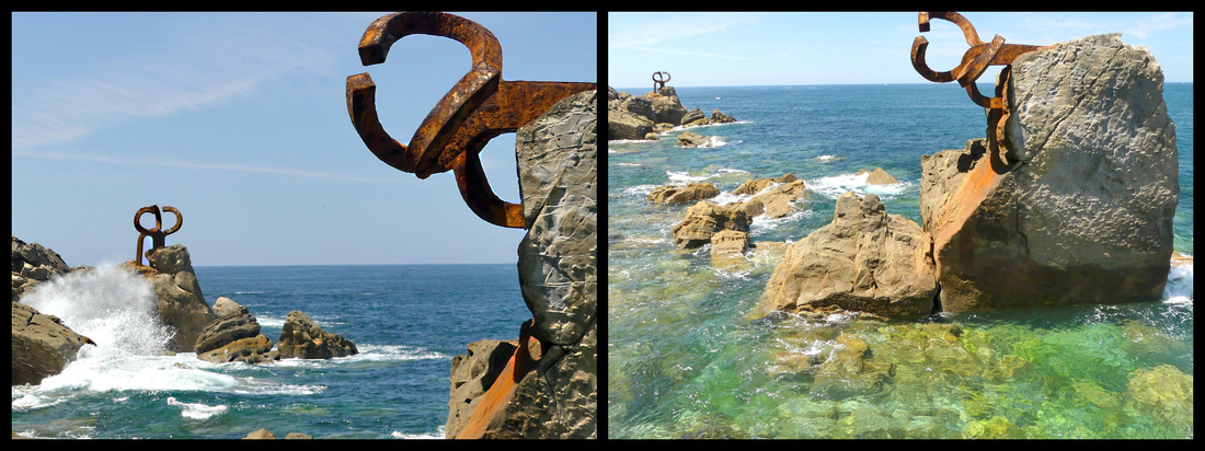 El Peine de Viento Sculpute
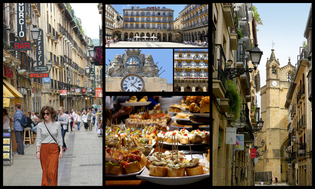
At the other end of La Concha Plage is The City Hall on a small plaza, which opens into a tiny park with flowers and a carousel, Parque de Alderdi-Eder. The city hall was originally a casino when it was built in 1897 until 1924.
El Muelle - Beyond the town hall, the Paseo ends at San Sebastian’s small fishing and recreational harbor, El Muelle. There is a passage through the wall at the appropriately named Calle Puerto into the old town. The other side of the harbor, a wide promenade, Paseo Nuevo, encircles Monte Urgull, with panoramic vistas of the Bay of Biscay and goes all the way around to the Urumea River. There is another rusty metal sculpture here, the Construction Vide, not quite as interesting as El Peine del Viento,.
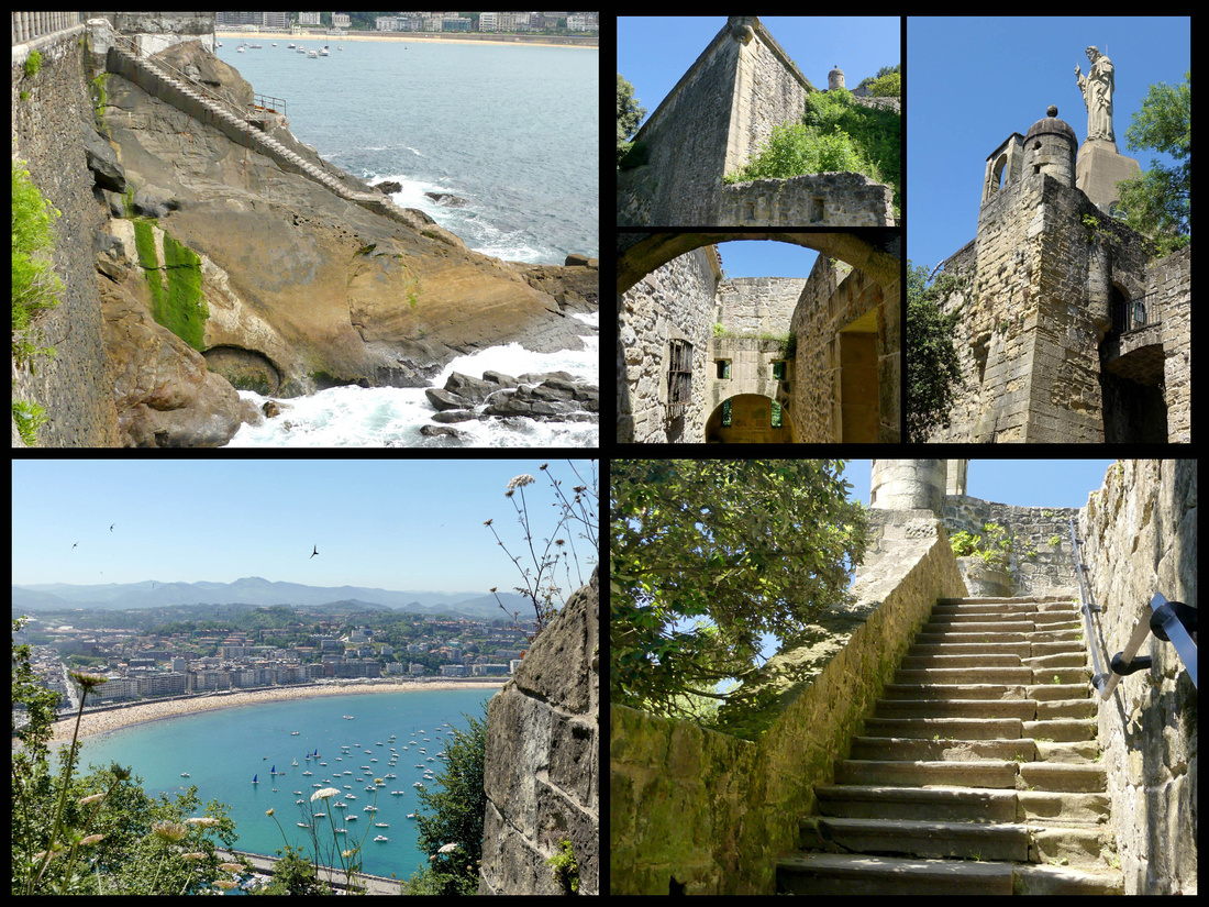
Monte Urgull - A once mighty castle (Castillo de la Mota), 12th century, is atop Monte Urgull, as are views. The best are not from the statue of Christ, at the very top, but from the ramparts of the left side as you face the hill, just above the port’s aquarium. You can walk up there via several paths from behind the aquarium, or from just above the old town. There are paths, steps and combinations of the two, and you can’t get lost, they all end up at the same place. On my way up I saw what I think was a bobcat.
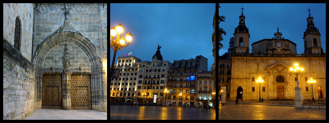
The Parte Vieje, ‘old town’, fills the neck of Monte Urgull, the bay’s eastern headland. There are shops and residences but mostly what there is are pintxos bars, seems like hundreds of them. The old town is mostly deserted in the morning, but it’s like party central in the evening. The main (pedestrianized) street, Calle Mayor, starts at the city hall and ends at Eglise Santa Maria, an 18th century Baroque church. It was built on the site of an ancient Roman temple. The church has a splendid Churrigueresco facade with a statue of Saint Sebastian in a niche and two towers. Looking in the opposite direction down Calle Mayor you can see the spire of the cathedral.
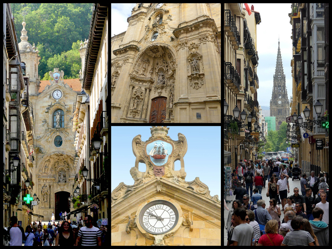
Down Calle 31 de Agosto, the only street that survived the fire in 1813, is Eglise San Vicente - thought to be the oldest building in San Sebastián. Its origins date to the 12th century, but it was rebuilt in its current Gothic form in the early 1500s. Buried in the center of the old town is it’s only real square, Plaza de la Constitucion - bullfights used to be held there and the seat numbering on the balconies remains. Lots of cafes.
Left: side street in the old town, top center: Plaza de la Constitucion Right: Eglise San Vicente
The old town is neatly underlined to the south by the Alameda del Boulevard a broad avenue with cars on one side and a grassy area with plane trees, grass and flowers in the center, and a wide pedestrian walk on the other. There is a band-shell in the center and it ends at City Hall sitting in the Parque de Alderdi-Eder at the top of the promenade, which in turn merges with the Paseo de la Concha. Mercado de la Bretxa , a sandstone market building facing the Alameda del boulevard is now mostly a modern shopping complex, with a McDonalds (with a very good McCafe). The produce market still takes place mornings along side the building.
Just below Alameda del Boulevard is the “Romantic Area” – the Belle Époque area that reminds you of Paris and Barcelona. The Plaza de Gipuzkoa is in the middle and in the center of it is a miniature park, complete with a pond with two swans and a tiny waterfall. That’s where the bus to Hondarribia leaves from. Classy place for a bus stop. Many of the streets are pedestrianized, full of stores including some of the international chains such as H&M and Sephora, etc. The Avenida de La Libertad runs parallel to the Alameda a few blocks south, lined with elegant buildings and a row of white iron Art Noveau lamp posts in the center.
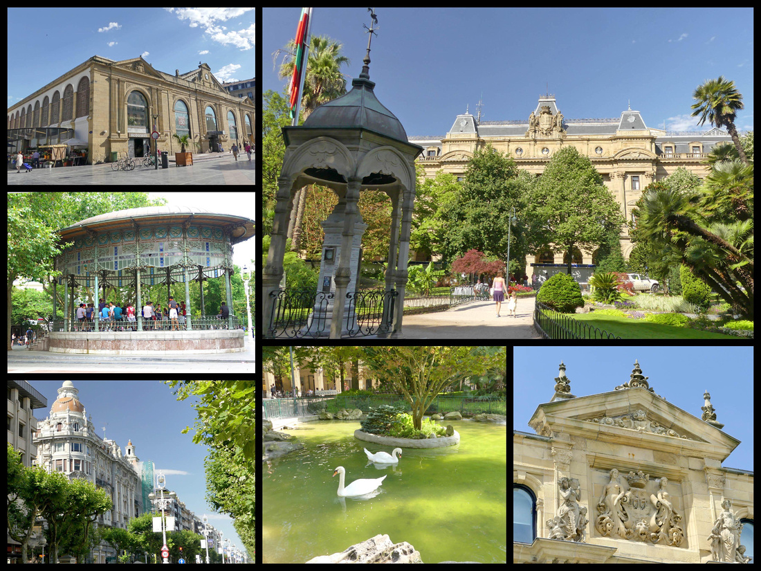 top left: Mercado top and bottom right: Plaza de Gipuzkoa bottom left: Avenida de La Libertad
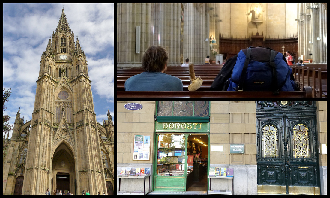
The area continues several more blocks to the Catedral del Buen Pastor - The largest church in San Sebastian, the Cathedral of the Good Shepherd, is in the New Town. This Neo-Gothic cathedral was designed by a Basque architect in 1880 and completed in 1897. With its 75-meter-high tower, it is an important city landmark. The cathedral was built out of sandstone from the Monte Igueldo.
Between the Cathedral and the river is a tiny plaza, Plaza de Bilbao, with a fountain in the center and some nice Art Noveau shop fronts.
A block from there is the Rio Urumea and the most impressive of the bridges, Puente de Maria Christina (1905). Between Puente de Maria Christina and the next bridge, Puente de Sta. Catarina, both sides of the river are lined with elegant buildings and fronted with park like tree shaded promenades. The next stretch, to the last bridge, Puente de Zurriola (with modernist, art-deco lampposts built in 1921) features two Belle Époque buildings, the Hotel Maria Christina and the Theatre Vicyoria Eugenia. In most cities this riverfront would be a main attraction, but given San Sebastian’s gorgeous sea front it sort of takes second place.
The river opens up to the ocean with Monte Urgull on one side and the Zurriola Plage on the other. A large modern building, the Kursaal Congress Center, was designed to look like two rocks stranded on the seashore.
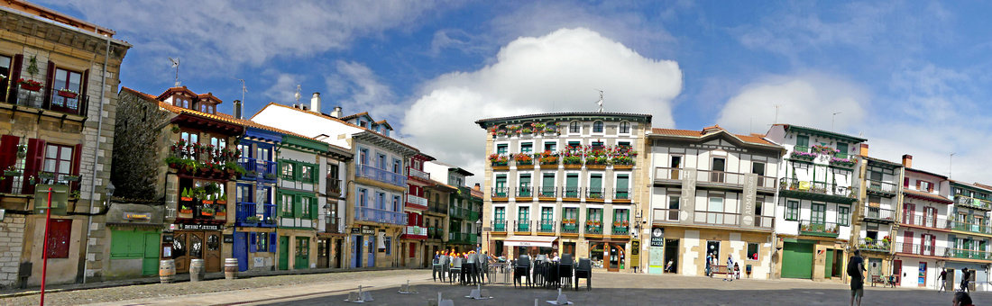
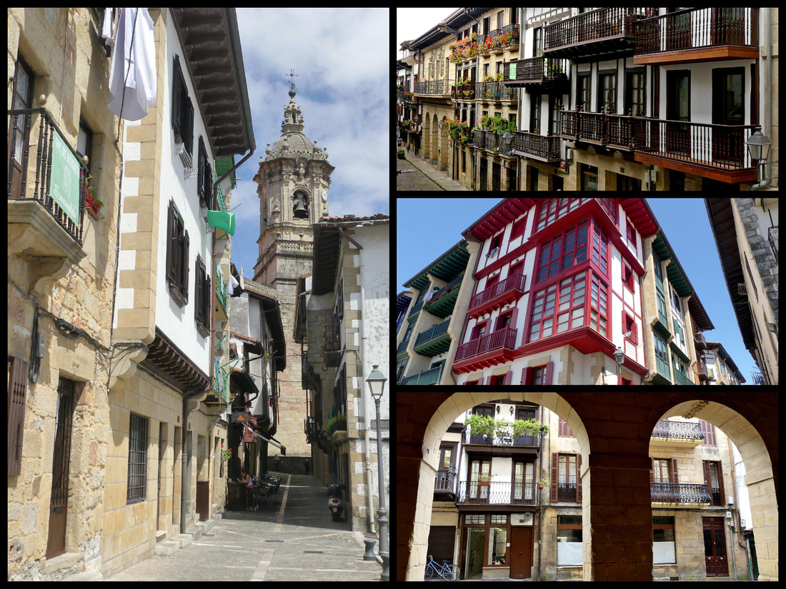
HONDARRIBIA Camino del Norte
Gipuzkoa Plaza in San Sebastian is where the buses leave from for Hondarribia. There are several bus stops (a bench with plexi glass enclosure and signs listing the routes) along one side of the plaza, at least three of which go to Hondarribia, the E 20, 21 and 27. www.lurraldesbus.eus). They are pretty frequent, each line goes once or twice an hour. I took the E20 there and it does go through a lot of suburban sprawl and takes close to 45 minutes. The E21 is the express and goes via the highway taking about ½ hour. I got that one coming back. But either will do. There are two stops in Hondarribia between the old walled town on the hill and the harbor – really just the one main street. The first one is just below the Santa Maria Gate and the other is at the other end of the walled town, just before the “fisherman’s village”. Literally about a minute apart so doesn’t matter which one you get on/off at.
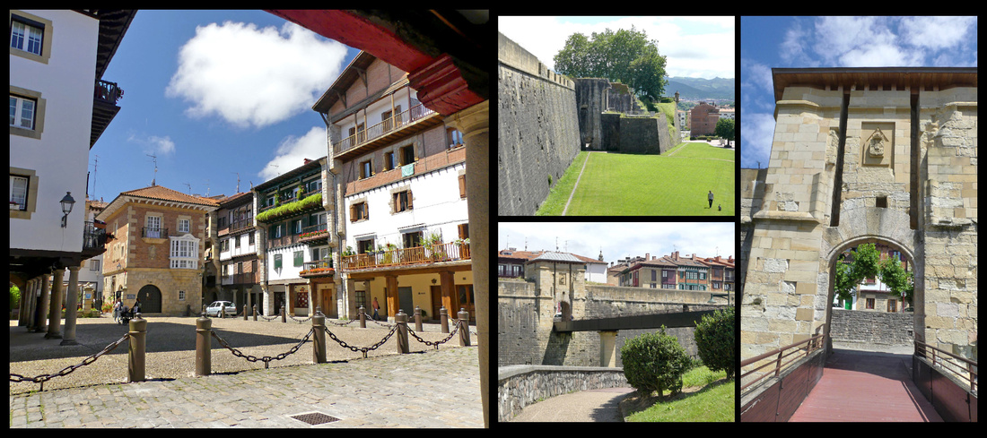
The border town of Hondarribia is one of the most historic and pleasant towns in the region. Almost completely free of tourists, it’s a well-preserved town surrounded by 15th century fortified walls, the only one in Guipuzcoa province. There’s a fishing port, a marina, and a beach, but the most charming area of Hondarribia is the walled part, a hilly grid of cobbled streets entered through arched gates. But the whole town is tiny, could be crossed on foot in less than half an hour.
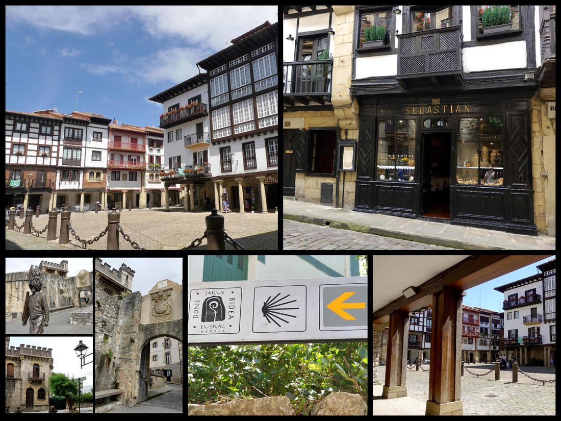
The main square, at the top of the town is Plaza de Armas, with colorful houses on two sides, the Castle of Charles V, built around 1190, and today the Parador, on the third side and views across the bay to France on the fourth . The Castle’s location on the hill overlooking the Bidasoa River, Hendaye and Txingudi Bay, made it the perfect position for defensive purposes. Just off the plaza is the Church of Santa Maria de La Asuncion y Del Manzano, built in the 15th and 16th centuries on the remains of the town’s original fortified walls, mostly Gothic with some Renaissance features. The belfry is 18th century Baroque.
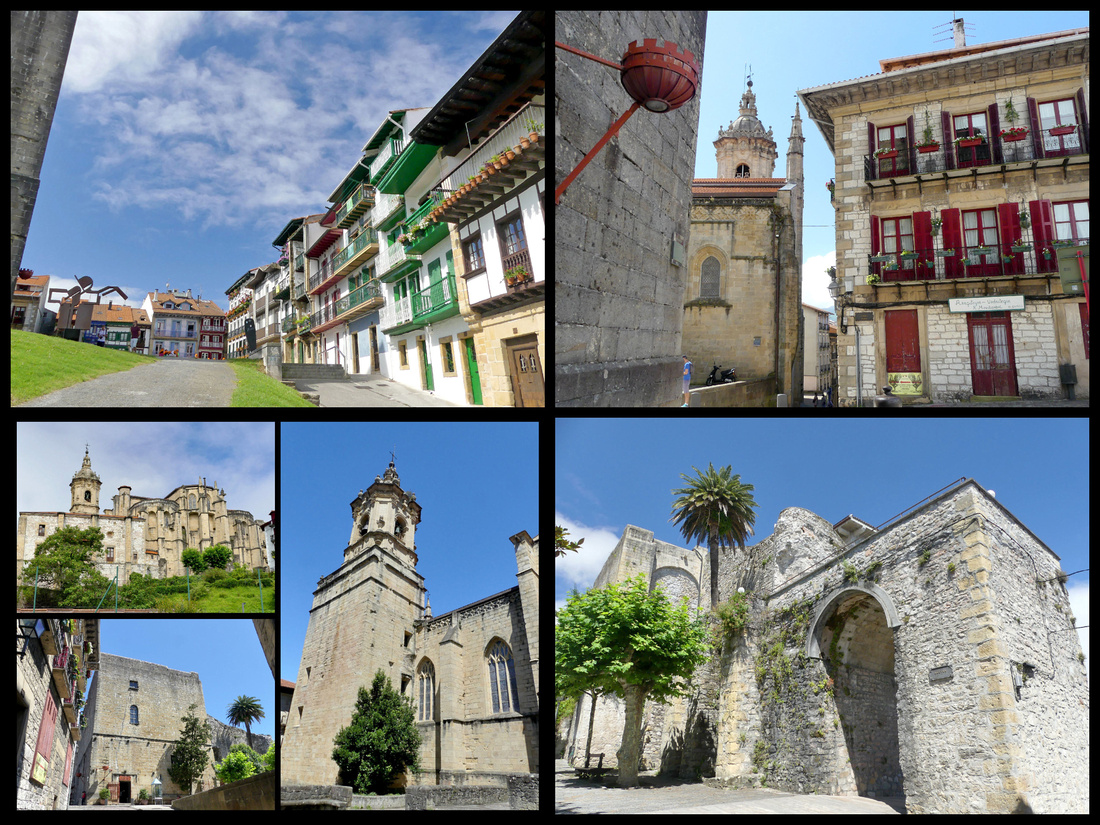
The main street, leading down hill from Plaza de Armas to the Santa Maria Gate is Calle Mayor (Kale Nagusia in Basque) The cobbled street, is lined with 17th and 18th century buildings featuring carved beams under the eaves, wrought iron balconies and family crests. Santa Maria Gate is one of two original entrances to the town, there used to be a draw bridge, guard house and moat here. Over the gate is the town’s coat of arms and over that a sun dial.
The Queen’s Bastion, built in the 16th century where the two main sections of the wall come together.
The other main plaza is Gipuzkoa Plaza , cobbled and small but with ornate buildings overhanging a wooden colonnade. This area was originally entered through San Nicolás Gate. In the 15-16th centuries this door was the village's main entrance. Originally a chapel, a tower, two doors and two bridges (one that could be raised and lowered and the other fixed) to cross over the moat formed the compound.
Santiago Street leads from Gipuzkoa Plaza down to the old fishing quarter. It was the first street in town and was used by pilgrims en route to Santiago. In modern times the first stage of the coastal Way of St James takes pilgrims through this town. Many maps list the town of Irun as the start of the Camino del Norte but Hondarribia was the original town at the start of this Camino and still truly is (Irun has more public transportation so many pilgrims start there, but it would be a big mistake to skip Hondarribia).
Down hill and outside the walls San Pedro Street is the main street of the old fishing village, known as the Marina District. The colors of the houses reflected those of the local fishing boats. The oldest building on the street dates to 1575. Today it is filled with restaurants and shops, lined with plane trees and benches. I got a chicken pastry thing for lunch, along with an ice tea and ate on a bench while people watching. The shop I got it in had mostly sweets and though the sign said ‘poullet’ I wasn’t entirely sure. The woman spoke no English but did the chicken dance to let me know what it was. Love sign language to overcome the language barrier.
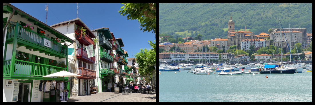
From the marina a tiny boat shuttles between Hondarribia and Hendaye, France (1.90€, summer only). The ride takes about 10 minutes and it runs every half hour.
Hendaye, France
Just on the other side of the river from Hondarribia, Hendaye’s location on the border has made it an important point for commerce between Spain and France. Historically speaking, the location has also proven to be problematic for the town since it has been involved in every conflict between the two countries. There’s a long beach (with surf) and streets of Basque style houses, a castle, the Chateau Abbadia, and good views of the flysch rock formations that are accessible on coastal walking paths.
Ondarraitz Beach has a long promenade next to it which is known as the “Boulevard de la Mer.” About halfway down the promenade there is the “Old Croisière Casino,” a building that stands out, not just because it is the only building located on the beach itself but also because it has its own particular style. Built in 1884, this is the only building in Hendaye that has an Arabic architectural style. For over 70 years, until 1980, the Old Croisière Casino was used as a casino. Today, it is a luxury residence and also a shopping mall.
At the end of the beach, are two rocks just off the coast called the twin rocks (“les deux jumeaux” in French). The legend around these rocks says that one day a Basajaun (a bigfoot like creature from Basque mythology) was in the Basque mountains and he tried to throw a rock to destroy the town of Bayonne. However, in doing so, he tripped and the rock fell out of his hand, broke in two and landed in the water of Hendaye beach.
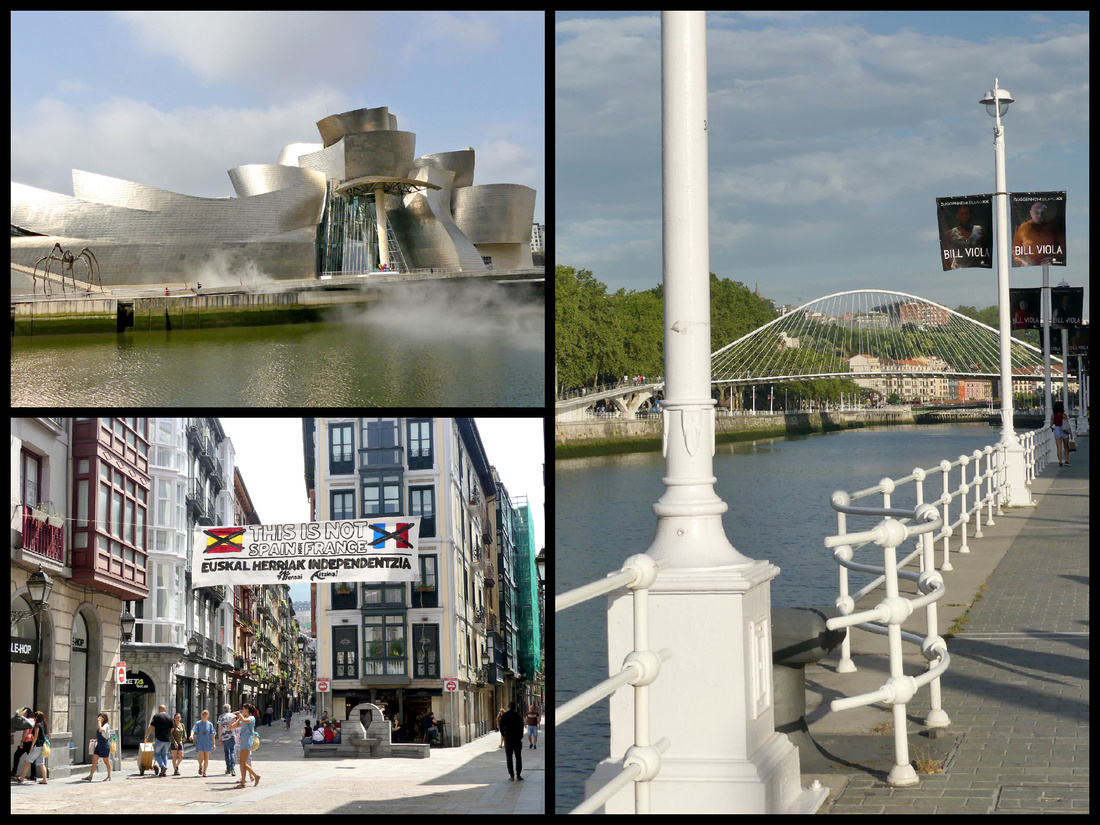
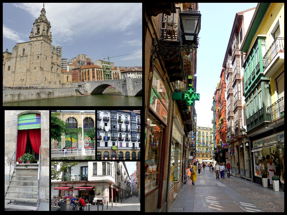
BILBAO Camino del Norte
Bilbao, Spain's sixth-largest city and biggest port, has been described as an ugly, gray, decaying, city. The metropolitan area has the highest population in the Basque region; including the suburbs and surrounding towns, Bilbao has over a million inhabitants. After the museum opened, 20 years ago, whole sections of the city were cleaned up and rebuilt. The river has wide pedestrian walks on both sides, with trees and benches. Some nice buildings but most seem to be mid-late 20th century boring. Some are nicely colored. But not quite the charm of Italy or some other Spanish towns. Still, the old town and the river are very pleasant. The ‘new’ part of Bilbao has some very nice buildings scattered around, but they are overshadowed by boring mid 20th century cement and steel buildings so the overall ambiance is nothing special. There are a few impressive modern glass skyscrapers. It’s not a bad city, but nothing you would really go out of the way for – if it weren’t for the Guggenheim.
The bus ride from San Sebastian to Bilbao passed the ocean a couple times, and a few pleasant vistas of hills and farms but mostly it went through two medium sized ugly towns that I never heard of and took forever to drive through (to pick up or drop off one passenger each) or else highway. Driving through the suburbs of Bilbao was mostly ugly sprawl. As we were turning into the bus station I did see the tram so knew where to walk to get to it, (area around the bus station is confusing at first but there are two tram stops and a metro stop within 5 minutes walk).
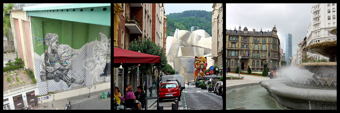
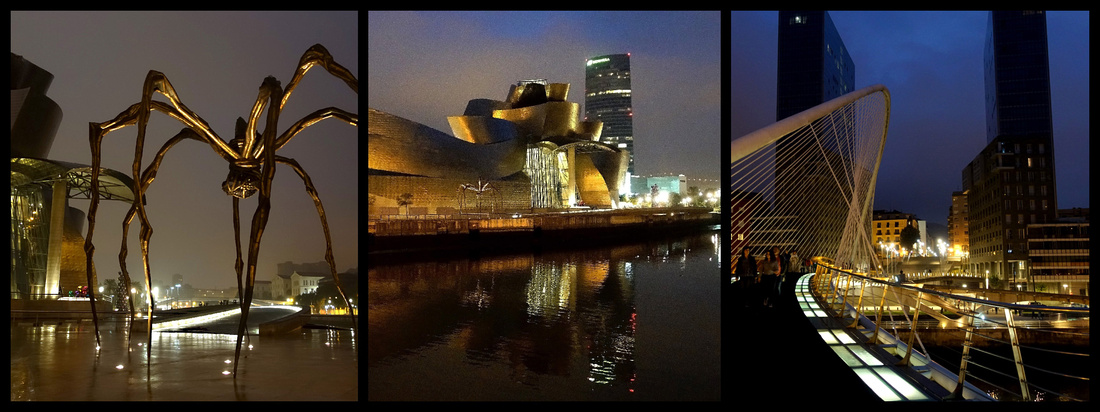
The Guggenheim Museum is without a doubt the main attraction of Bilbao. Designed by architect Frank Gehry, the museum opened to the public in 1997 and has since been hailed by both the public and critics as one of the most important structures of contemporary architecture in the world. The building is wrapped in titanium panels that create what appears to be random organic curves. These panels were designed to capture light. For this reason, the building takes on a different appearance at night as the city lights reflect off it. Also, when viewed from the river, it resembles a ship (albeit abstract) and the panels are reminiscent of fish scales. Both of these attributes pay homage to the fact that the river was historically the economic hub of Bilbao. In the Atrium, the central interior hall that is a signature feature of Gehry's architecture, paintings are displayed along the walls of the curved walkway in a three-level staircase. Gehry’s masterstroke was to use titanium, an expensive soft metal used in airplanes. He was intrigued by its futuristic sheen and malleable qualities; the panels are literally paper-thin. The titanium makes the building shimmer: it seems to capture motion. Giant windows allow in natural light. The building also interacts fluidly with the river itself; the pool at the museum’s feet almost seems part of the Rio Nervión, a few feet away, and the mist sculpture, when turned on, further blurs things. It’s entitled FOG, which also happen to be the architect’s initials. The same pool also has Fire Fountain pyrotechnics at night.
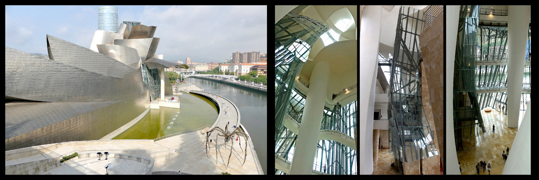
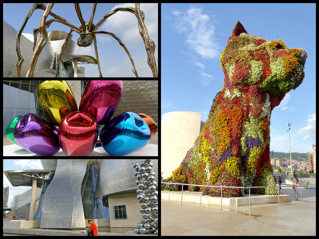
Outside the museum itself, Jeff Koons’s giant floral sculpture, “Puppy”, sits eagerly greeting visitors. Initially a touring attraction visiting the city for the opening of the museum in 1997, Bilbaínos demanded that he stayed put. On the other side of the building, a sinister spider-like creature guards the waterside approach. It’s a striking piece of work, and makes a bizarre sight if approached when the mist is on. More comforting are Koons’s colorful bunch of Tulips by the pool under the gallery’s eaves.
Inside, massive Gallery 104, built with the realization that many modern artworks are too big for traditional museums, has been dedicated to Richard Serra’s “The Matter of Time”, an installation consisting of eight monumental structures of curved oxidized steel. A hundred feet long, and weighing 180 tons, it’s meant to be interactive – walk through it, talk through it, touch it. Other galleries feature ‘traditional’ modern art. The entire second floor is dedicated to temporary exhibits and while I was there it was Bill Viola a video artist whose work heavily features water. The third floor is their permanent exhibit which includes one Monet and a number of post-impressionists that were nice, plus some more modern stuff like Warhol (150 Marilyn Monroe faces), etc. I like that there were only a few rooms of each kind of art from late 1900s through 20th century. There was also some sculpture by Eduardo Chillida who did the Wind Sculpture in San Sebastian and an exhibit about turn of the (last) century Paris.
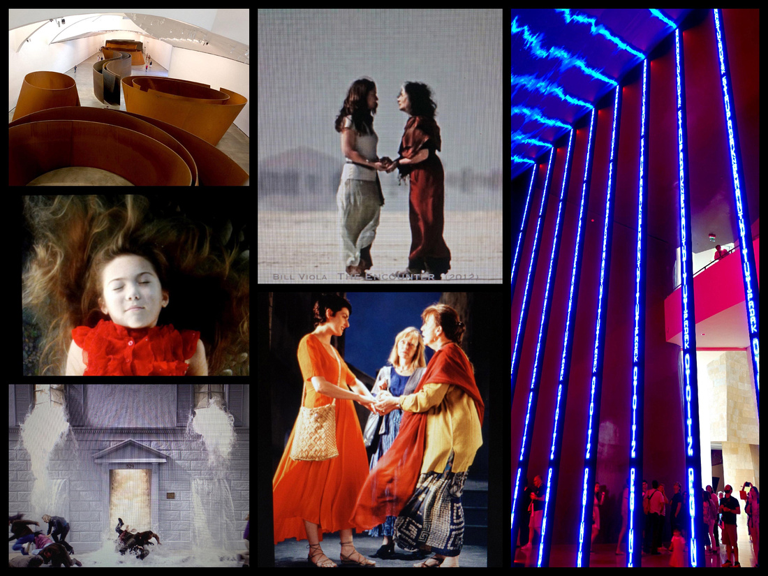
Top left "Matter of Time" steel installation, remaining photos are all Bill Viola works
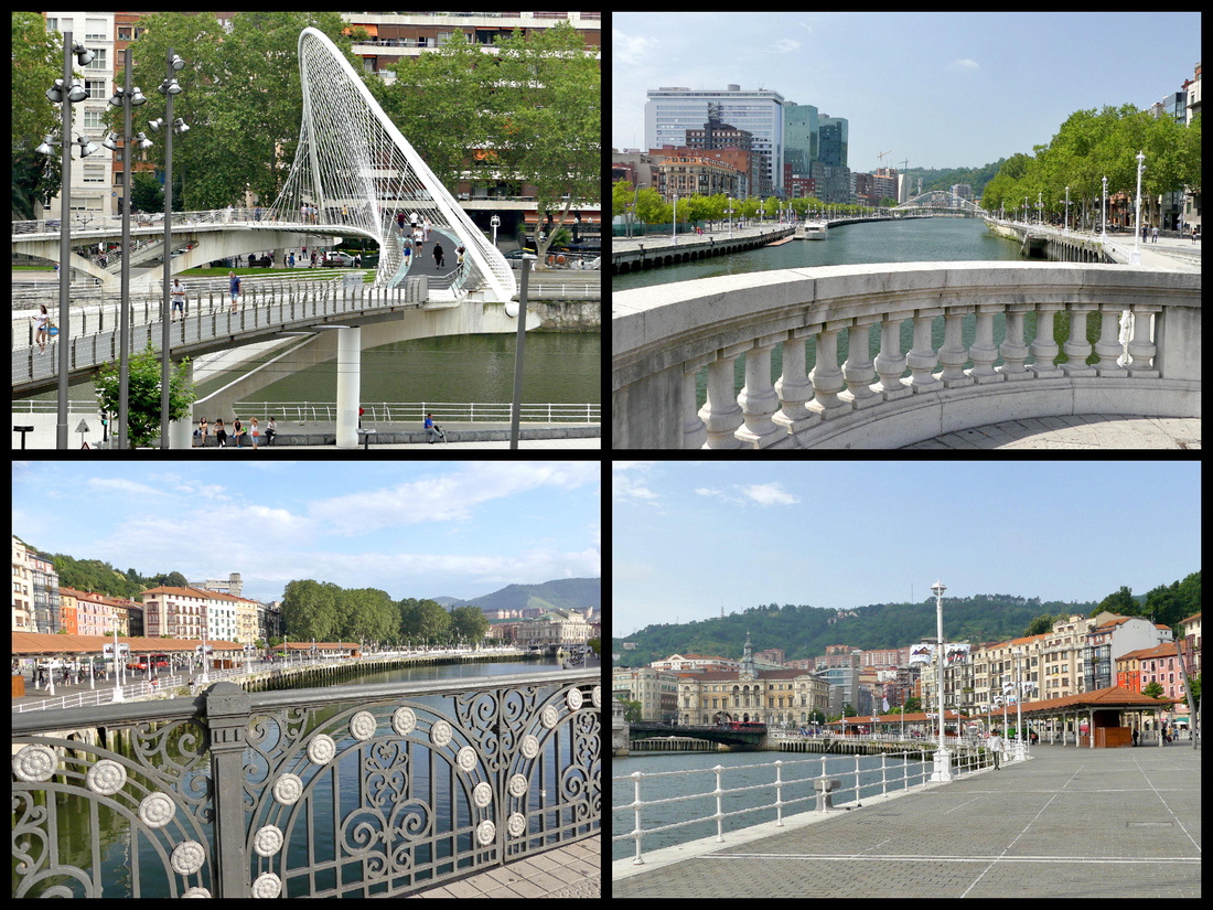
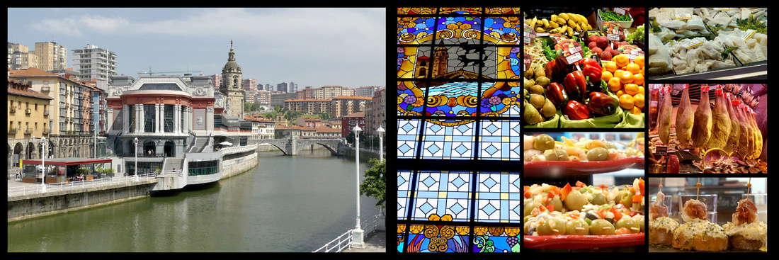
The Nervión River meanders through Bilbao, whose historic core was built inside one of its loops, with water protecting it on three sides. Now there are promenades on both sides with parks, benches, playgrounds, etc. and crossed by several bridges, the most striking being the Zubizuri (which is Basque for ‘white bridge’, also called Puente del Campo Volantin) footbridge. Opened in 1997, the bridge's unusual design consists of a curved walkway which is supported by steel suspension cables from an overhead arch. The structure of the bridge is painted white and the bridge deck consists of translucent glass bricks. Hotel Conde Duque is right at the foot of the bridge, ten minute walk from the Guggenheim in one direction and the old town in the other.
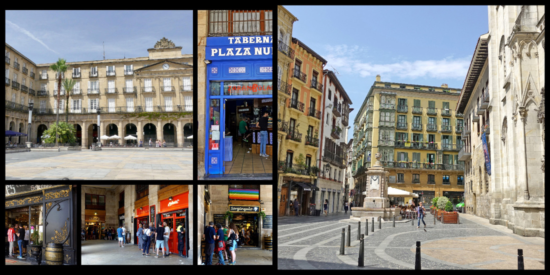
The Casco Viejo of Bilbao is also known as “las 7 calles” (Siete Calles) or “Zazpi Kaleak” in Basque (the seven streets), since these were the seven streets that formed the original medieval town. Full of Old World charm, the Casco Viejo is on the right bank of the river extending between the San Antón Bridge and the Church of San Nicolás. The beautiful narrow streets are mostly pedestrian-only. More ‘up-scale’ than many European Old Towns, the buildings are several stories high, colorful, and with iron balconies featuring flower boxes. Numerous ones feature glassed in balconies. Plenty of pintxos bars but also lots of shops – produce, meat, fish, bakeries, clothing (including some international chains).
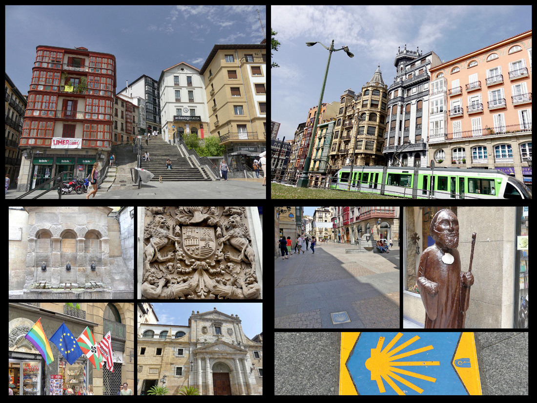
Bilbao's old town. The cute little green tram is the best way to get around Bilbao. The Camino goes right through the center o the old town.
Formerly an area of marshy sand, the Arenal was drained in the 18th century. It is now a busy nexus point for strollers, and dog walkers, and has a bandstand. The beginning of the Old Town it is joined to the other side of town by Puente del Arenal and the Paseo del Arenal.
Iglesia de San Nicolás de Bari. has a Baroque facade and an octagonally shaped interior; the church dates from the 14th century but was completely rebuilt in 1756.
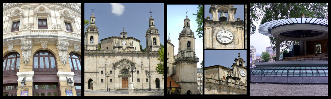
Plaza de Arriaga / Teatro Arriaga, across the street from the Arenal, is an elegant Neo-Baroque theater that was inspired by the Palais Garnier Opera House in Paris. Built in 1890 and later renovated, the Arriaga Theater is the cultural hub of the city where classical music concerts, opera, and theater performances are staged. Was only reopened in 1986 after decades of neglect. It’s very much in plush fin de siècle theatre style, with chandeliers, soft carpet and sweeping staircases.
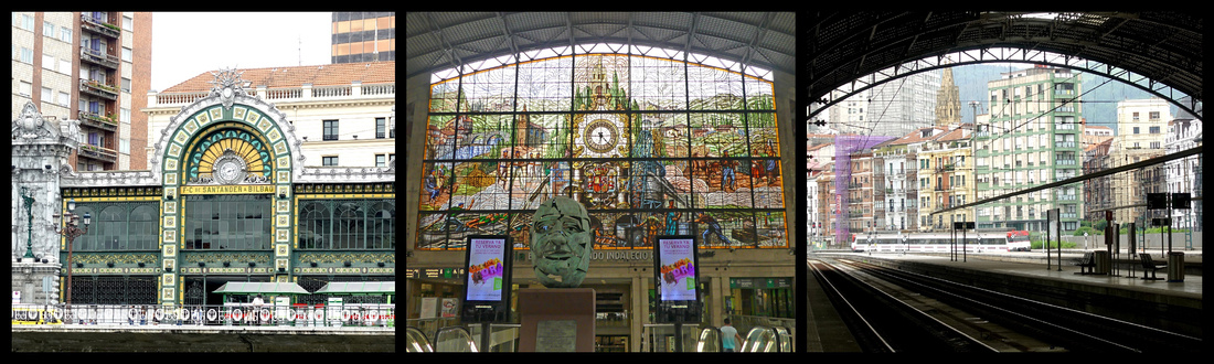
Abando train station – Across the river from the Theater. Both the side facing the river, and the giant stained glass window upstairs where the trains depart are beautiful, especially for a train station.
Plaza Nueva (Plaza de los Martires)- finished in 1849 and enclosed by elegant arcaded buildings featuring cafés and bars with outdoor terraces, also used for town festivals and farmers markets. More formal and symmetrical than most of the old town with courtly neoclassical arches.
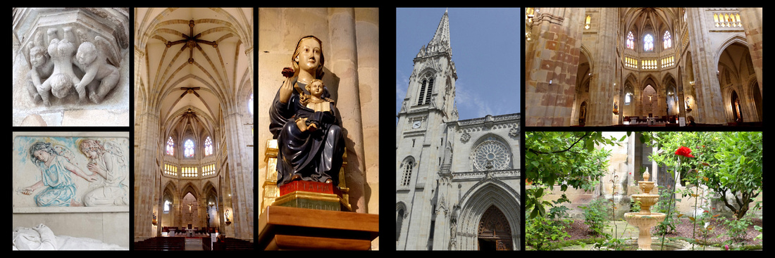
Catedral de Santiago, built in the 14th century and then restored in the 16th century after a fire. Gothic. The cathedral's facade was rebuilt in the 19th century. Slender spire rises high above the tight streets. A graceful Gothic affair, two of its best features are later additions: an arched southern porch and a small but harmonious cloister.
Mercado de la Ribera, art deco building from 1930 sits on the riverbank. The 10,000-square-meter space is one of Europe's largest indoor marketplaces. A bright and cheerful space, the market hall has skylights above and a floor made of clear, translucent material that allows light to flood into the building. The exterior features whimsical Art Deco designs, floral decorations, and lattice windows. This is the main place in the city to find high-quality Basque culinary products, fresh fruits and vegetables, seafood, and other gourmet food products plus there is a great assortment of pintxos bars.
San Antón top left, on the edge of the old town.
El Ensanche, the new town, while a little grey and with a bit too high a percentage of boring late 20th century buildings, does manage to have an elegant European feel to it. There are stately banks and international shops lining the avenues. When the small Casco Viejo area became too small for the population in 1876 the Plan de Ensanche (expansion) was approved, and the area across the river was designed governed by the curve of the Nervión. The Ensanche quickly became Bilbao’s business district, and it remains so today.
BIZKAIA BRIDGE - Portugalete/Getxo Camino del Norte
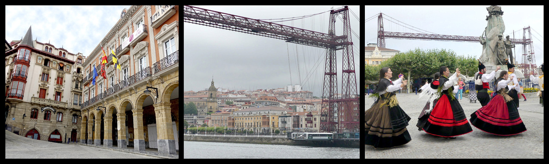
A twenty minute ride on the metro to either town (3.60€ RT) and a ride across the river on the Bizkaia Bridge('vis-KAI-ya') Gondola (.40 – or €8 to walk across the top). Located on the final stretch of the Bilbao’s Ría, where it flows out into the Bay of Biscay, the bridge links Portugalete ('por-Tu-a-lay-te')and Getxo ('gets-co'), two towns, the former with winding mediaeval streets and the latter more of a grid pattern with larger, newer, town houses. UNESCO World Heritage Site. It was the first metal transporter bridge in the world and is considered a masterpiece of engineering of its time. It was opened in 1893 and has been in operation ever since. A bizarre cross between a bridge and a ferry, it was opened at a time when large steel structures were à la mode in Europe. Wanting to connect the estuary towns of Getxo and Portugalete by road, but not wanting a bridge that would block the ría to shipping, the solution taken was to use a ‘gondola’ suspended by cables from a high steel span. The modern gondola goes back and forth with six cars plus foot passengers aboard. You also see the bridge referred to as the Puente Colgante (hanging bridge). It’s very tall, and the mechanics of it very interesting, but otherwise not especially beautiful to look at.
Very much separate towns rather than suburbs of Bilbao, Getxo is a wealthy, sprawling district encompassing the eastern side of the river mouth, a couple of beaches and a modern marina. Portugalete is a hill town on the other side of the river with several old buildings, some winding streets and nice plazas. Both have riverfront promenades. In both directions there is evidence of the shipping industry but that is a ways from these towns. Portugalete is by far the more interesting one to wander around. There was a group in folk costumes playing bagpipes, drums, etc. and dancing so that certainly added to the ambiance.
I took the metro (‘average’, very functional but boring cars, boring stations) to Portugalete. About 25 minutes. Between the one sign (TI and bridge) and common sense (go down the hill not up) I found the main part of the old town and the bridge.
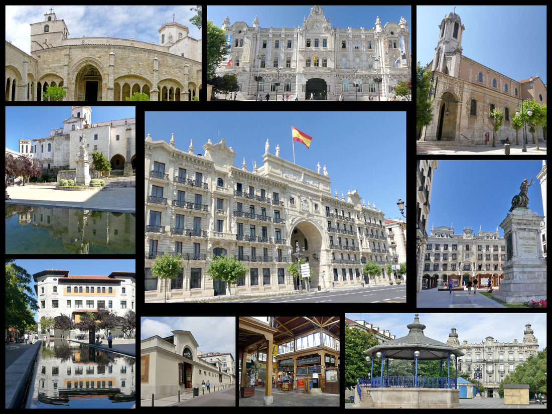
SANTANDER [Camino del Norte]
Santander, population 200,000 is a coastal city with an extensive south facing bay (the only one on the north coast of Spain), the narrow Bahía de Santander. From the heart of the city, you can see across the bay to rolling green hills and (on clear days) the high mountains of the Picos de Europa (I only saw these on my last of three days, and only in the evening). Originally it was a fisherman’s town but today it’s main activities are industry, commercial port and tourism. In the 18th and 19th century it was a major port for maritime routes between Castile and America. A huge fire in 1941 destroyed most of the historic district. In 1983 the Autonomous Community of Cantabria was created and Santander became it’s capital. It is on the Camino del Norte.
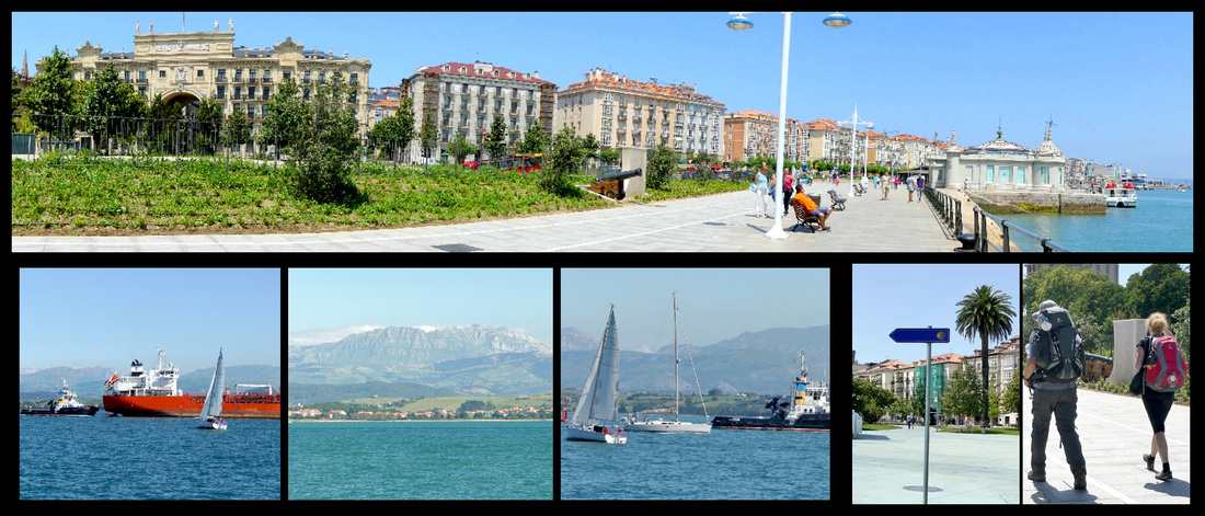
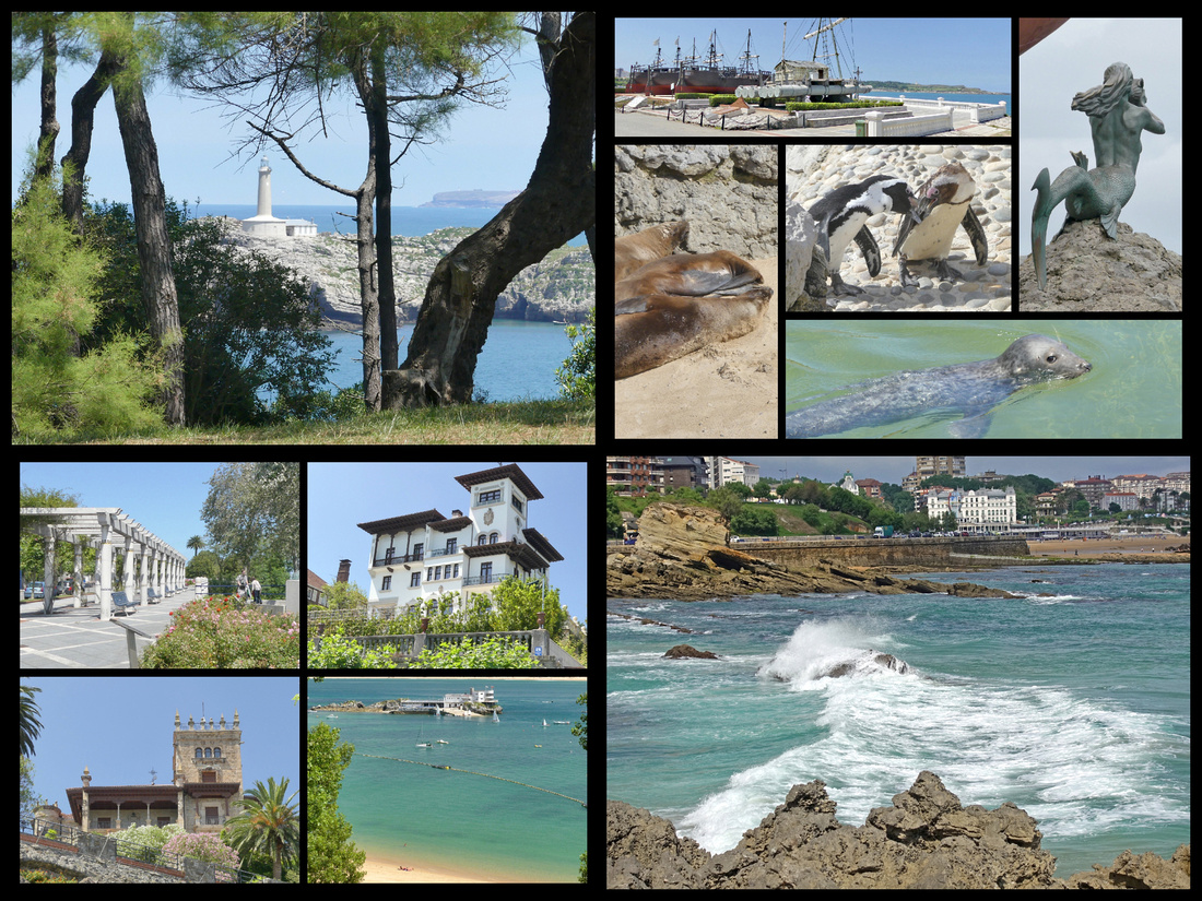
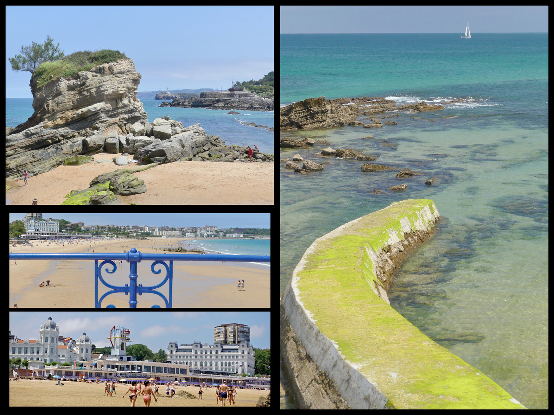
Paseo de Pereda – a long waterfront area on the Bahia (the narrow bay, not the ocean) stretches between the industrial/commercial area and the Magdalena Peninsula. Beginning at the Jardines de Pereda, the promenade continues to Puertochino, the leisure boat marina. Half the city strolls or jogs here on summer evenings. Both Paseo de Pereda and Calle Castelar, opposite the Puerto Chico, are lined with grand buildings flaunting typical glassed-in balconies. Puertochico was Santander's fishermen's port over 100 years ago, and before that commercial vessels docked there. It's home to a gigantic Spanish flag.
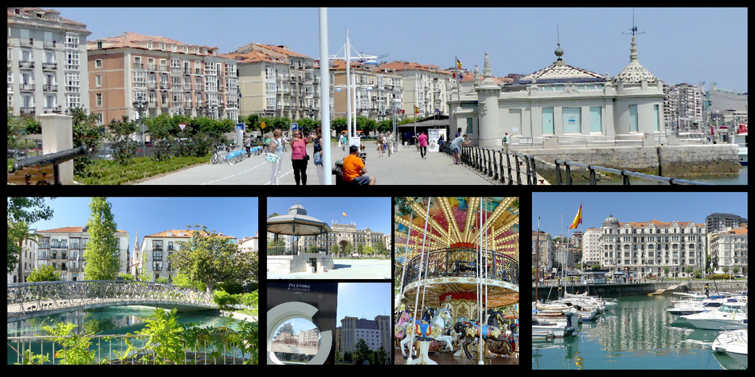
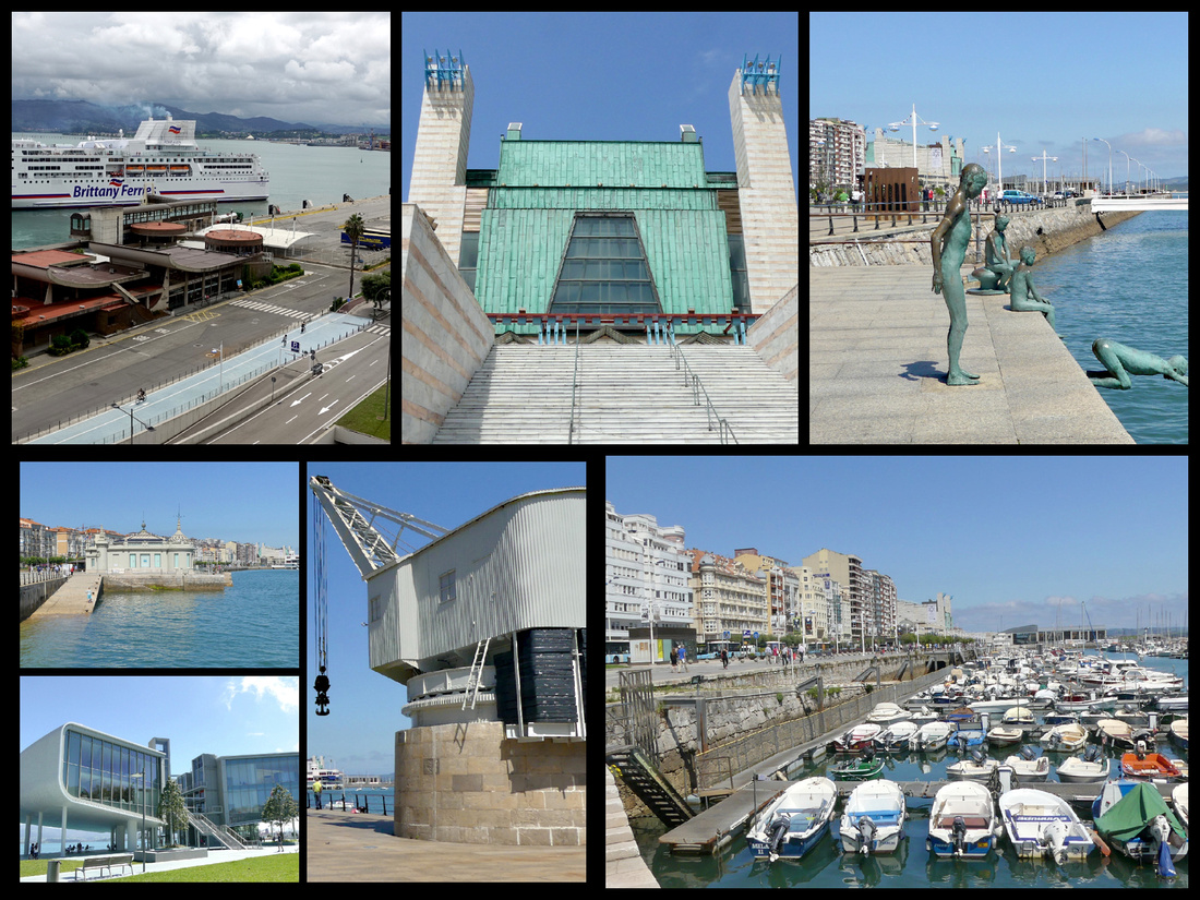
Just before the Jardines de Pereda is the Estacion Martima (ferry terminal) built in the 1970s, it’s roof designed to simulate the strong swell of the Cantabrian coast. Brittany Ferries from the UK docks there. Hotel Bahia overlooks it. Pereda Gardens are lovely with several sculptures, a small pond with a curved footbridge over it, a carousel. Post Office Building and the Bank of Spain building sit at one end of the garden. The area right behind here is where the huge fire began which burned much of the old city. There are interesting plaques all around showing what the area looked like before the fire.
The first building on the waterfront promenade is the Futuro Centro Botin, a futuristic building, in two parts, opened in June 2017, designed by the Italian architect Renzo Piano. The building is levitated from the promenade on slender pillars and clad with 360,000 ceramic discs finished with a mother of pearl glaze. It houses an exhibition center (Picasso and Goya, etc.) and cultural education programs, lectures and performances. Santander is hoping it becomes a major art-world destination, and that it will bring the kind of revenue and benefits known as the “Bilbao Effect”.
Next to that is Grua de Piedra, an old Stone Crane that served in the Port of Santander from 1900 until the end of the 20th century. It was used in the loading and unloading of the merchant ships that docked there. Palacete del Embarcadero, built in 1920, the former passenger station, is now an exhibition center.
Just past there is Escultura de los Raqueros - statues of boys on waterfront, in honor of poor or orphaned boys who used to wait for coins to be thrown at the sea and then dove for them.
After the Puertochico is the Palacio de Festivales Cultural Center, 1985, a gigantic theater and performance space. The promenade ends here and become woods and beaches. Steps lead up to Avenida de la Reina Victoria, which connects the Peninsula de la Magdalena with the center of the city and is lined with very upmarket houses (some of Northern Spain’s most expensive residences).
The Península de la Magdalena protects the bay of Santander from the Atlantic, at the tip is the Magdelana Palacio, a gift from the city to the king that now houses a summer university that draws people from around the globe. The building, 1908, is ‘like a child’s idea of a palace, surrounded on three sides by the sea.’ On the bay side of the peninsula are a couple of pretty beaches, Playa de la Magdalena and Playa de los Bikinis. On the sea side is the artificial Playa del Camello, named for the humped rock that sticks out of the water opposite it. The whole peninsula is a park and there are seals (2), sea lions (3) and penguins (several), and three replica Spanish galleons. The views of nearby beaches across the crashing sea are beautiful and both lighthouses are visible from here. And a bronze mermaid.
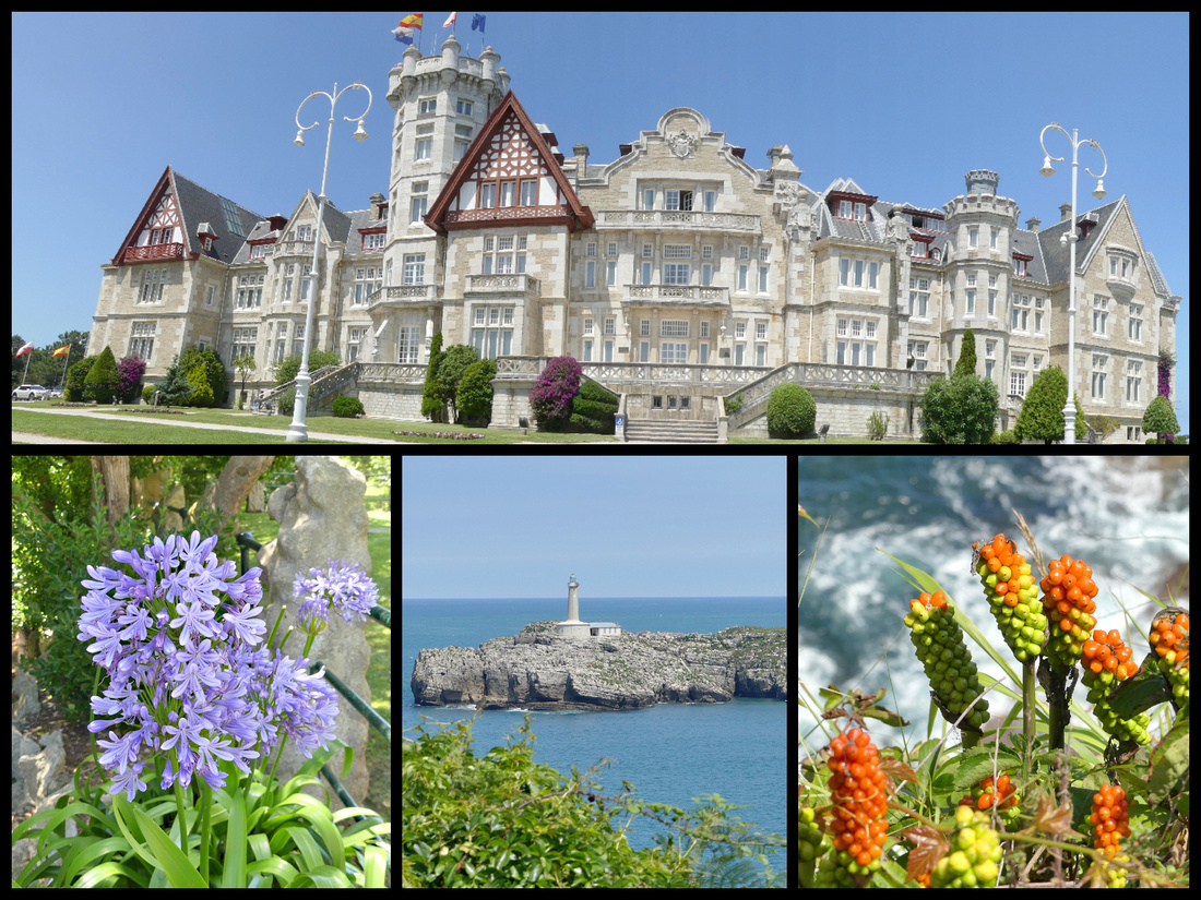
Plalya del Sardinero – a long beach between the Magdalena Peninsula and the Faro de Cabo Mayor headland has preserved the atmosphere of the Belle Époque era with elegant hotels, an elegantly restored casino and a scenic promenade perfect for coastal strolls. El Sardinero Beach is north of the Peninsula of La Magdalena, facing the Atlantic Ocean where the breaking surf can be dramatic.
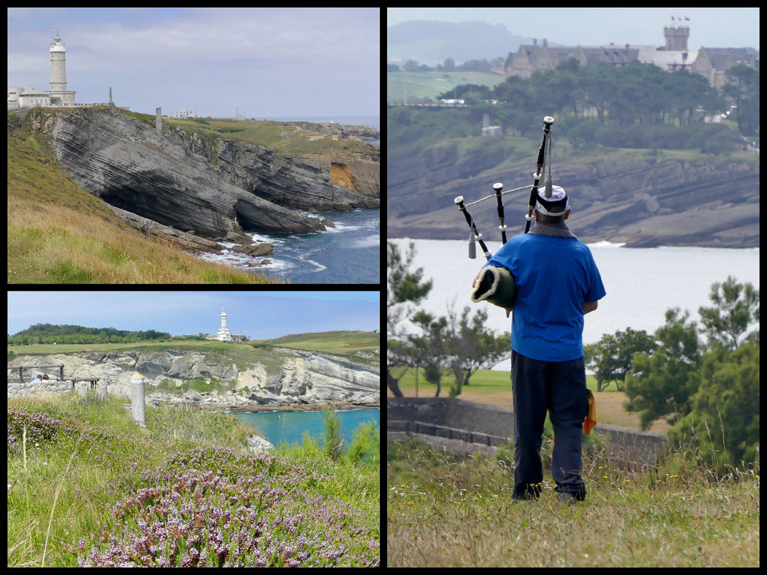
From the end of the beach, a coastal path begins that skirts a golf course around the Cabo Menor headland before reaching the Mataleñas (another beach) then up through a high meadow area overlooking the cliffs and the waves below and eventually comes to Faro de Cabo Mayor and the Puente Forado, an interesting formation shaped like a bridge that was carved by nature from the limestone rocks. ~3km
I walked along a path atop a headland with waves crashing on the rocks far below, through a large meadow, wild heather, the ocean, the lighthouse, a golf course off to one side, a stiff breeze – and bagpipes. I could have been in Scotland. And the sun came out and the clouds disappeared and the sky turned blue. Made up for the last couple weeks of mostly cloudy weather. Absolutely gorgeous.
There is not much left of the ‘old town’ due to the fire of 1941. Most of the buildings are mid 20th century but a lot were rebuilt in the traditional Santander style with glassed in balconies.
Santander Cathedral is composed of two Gothic Churches, one built over the other. The lower church, Iglesia del Santisimo Cristo was built during the 8th century, the upper church was begun later in the 8th century but had to be largely rebuilt after the fire of 1941. There is a 14th century cloister. The interior of the church is rather boring but the exterior is unusual, with large square towers rather than the usual steeples, and it’s built of white stone, also unusual among European cathedrals. The cloister is the more traditional golden stone and is lovely.
Banco de Santander building dominates the waterfront area. Going through its grand archway you enter the old quarter. An extraordinary and distinctive fin-de-siecle building - actually two, joined by a huge arch - that was the original head office of what has gone on to become one of the most important banks in the world. I’ve seen ‘Banco de Santanders’ all over Europe, used their cash machines many times so it was kind of cool to see the real thing.
Palazo Pombo – A medium sized open square with a round band shell in the center. The Church of Santa Lucía, 1864, has a beautiful Renaissance portico with large columns.
Mercado del Este, 1839, now houses several tapas bars, a florist and the main office of the TI
Plaza Porticada (64 porticos) one of the largest squares in the city was built with the idea of making it the central hub of the city, after it was devastated by fire in 1941.
Ayuntamiento - The building was built in 1907 in the same place where formerly stood the old convent of San Francisco. In the mid sixties it was enlarged to its present size.
Comments
https://elobr.com/author/albertosfz7228/
https://livein.gy/author/toryfairthorne/
https://www.travelmapsgo.com/katharinaautry
https://cutenite.com/@fran211609162
https://videos.recentstatus.com/@letafrewer4246?page=about
https://www.grupposolutio.it/agents/fawnvaldivia38/
https://web.ychatsocial.com/read-blog/9688_what-you-possibly-can-be-taught-from-invoice-gates-about-cashback-bonus-casino.html
https://git.maiasoft.jp/veolaandre234
https://winacess.com/employer/13289/moon-bingo-365
https://katibemaraty.com/@luciowallen81?page=about
https://mudate.com.co/author/shelliharvey18/
https://ciitiijobs.in/employer/mrq-casino-365/
http://dyln.fun/finleyserisier
https://newtew.com/read-blog/4137_heard-of-the-nice-mijn-account-bs-concept-right-here-is-a-great-instance.html
https://git.comzg.com/minniedennys8
https://jobwiser.in/employer/mega-riches-365/
http://129.204.4.238:3000/evelyn08010391/moon-bingo-casino-slots2034/wiki/The+Hidden+Mystery+Behind+Moon+Bingo+Promotional+Code
https://moyatcareers.co.ke/companies/vulkan-vegas-77/
http://47.76.126.2:3000/sabinewainwrig
https://indianmakaan.com/author/annmariephilli/
https://voicync.com/christymaccart
https://southpropertyfind.com/author/avisenright21/
https://mockway.cpolar.top/monteowen49527
https://git.comzg.com/johniemiljanov
https://shehayberrealty.com/author/harriettcolwel/
https://feelingspot.com/read-blog/4056_get-more-and-better-sex-with-download-for-mobile.html
http://124.222.84.206:3000/andersonpung03
https://www.huntsrecruitment.com/employer/vincispin-11/
https://axxessrealty.com/author/luciennehayes/
https://git.vsadygv.com/gabrielabrass1
http://47.99.84.40:3000/betseymacgeorg
https://alshirawirealestate.com/author/jorjatickell94/
https://mm.gd/read-blog/23670_by-no-means-altering-betting-options-will-finally-destroy-you.html
https://thesecurityexchange.com/employer/book-of-dead-777/
http://47.106.138.28:3000/rickie22633731
http://dev-gitlab.dev.sww.com.cn/santoeuler5900
https://fringz.ma/author/gertrudemadiga/
https://shoqaq.com/agents/rowenaschultz3/
https://git.shunyi.fun/chanteearl0498
https://deepsoundtest.sisond.com/erickggi214588